
Kariandusi Prehistoric Site
Kariandusi is a hillside of stone tools above Lake Elementaita, a few minutes off the Nairobi to Nakuru highway, and the easiest prehistoric site in Kenya to reach. Louis Leakey found it in 1928, it is one of the earliest sites of its kind identified in East Africa, and a visit takes under an hour.
What Was Found Here
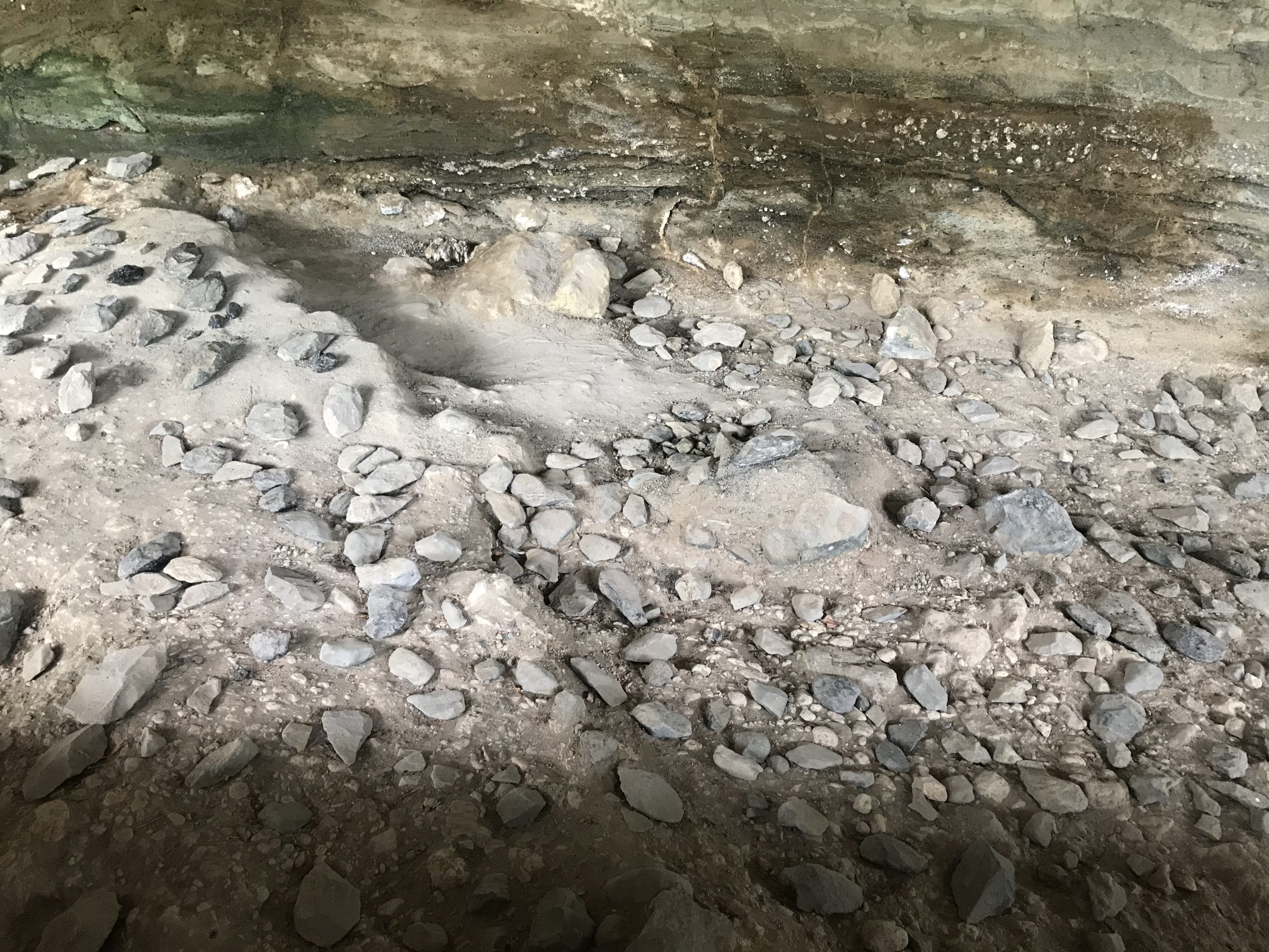
The National Museums of Kenya describes Kariandusi as the living site of what it calls the hand axe man, discovered in 1928 and identified by Leakey as a factory site from the quantity of tools in the riverbed. It calls the material Acheulian, ranks the site among the first discoveries of Lower Palaeolithic sites in East Africa, and states that Kariandusi is possibly the first Acheulian site found in situ there.
The tools are worked in obsidian and in trachyte, both volcanic and both local, and obsidian is what makes the site look different from other hand axe localities. It is black, glassy and sharp, and a hand axe struck from it looks nothing like a lump of rock.
The dating needs care, because this is exactly the kind of figure that goes wrong in travel writing. The National Museums of Kenya gives the site as between 700,000 and 1 million years old. Kenya Wildlife Service, on its Lake Elementaita page, describes the same excavations as having revealed Oldowan stone tools dating back approximately 700,000 years. Those two statements do not agree: Oldowan and Acheulean are different industries, and the second is the one the archaeological literature and the site’s own custodian use here. The honest position is to give both attributions and say which body said what.
A practical filter for any prehistory claim in a brochure: ask which site the material came from, what the dating method was, and whether the figure is a range or a point. Kariandusi is a range, and any page giving it as a single confident number has flattened it.
Why the Tools Are Where They Are
The explanation the site gives for itself is the best part of a visit. The National Museums of Kenya records that large lakes, at times hundreds of metres higher than the present Lake Nakuru and Lake Elementaita, once occupied this basin. Rising water drove the occupants off and buried what they left where they left it. The tools are not scattered across a landscape but lie in a bed, in place, under the sediment that covered them.
That is what an excavation here shows: a cut face with hand axes and flakes still lying in the layer, under a shelter, rather than objects removed to a display case.
What There Is to Do on Site
The visit is short and is mostly walking between the excavation shelters with a guide. There is an exhibition hall, a nature trail, a gorge, a picnic ground and camping space, and decent birding. Take the guide: the panels are thin and the tools are hard to read as tools without someone pointing out what a flake scar is and which end was held.
The National Museums of Kenya lists other things within reach, separately arranged and none run by the museum: the Church of Goodwill, a monumental colonial era church of the 1940s visited by arrangement with its caretaker; caves associated with the Mau Mau; Maji Moto, the local hot springs, managed by the community that reclaimed them; and the hand dug diatomite mine tunnels, the same lake sediment story seen from the commercial end.
Something worth noticing while standing there: more than 250 hand axes from Kariandusi are held at Cambridge alone, which is a fact about how excavation worked in the colonial period as much as about the site.
Getting to Kariandusi and What It Costs
The National Museums of Kenya places Kariandusi about 120 kilometres north north west of Nairobi and about 2 kilometres east of Lake Elementaita, on the Nakuru and Elementaita basin floor with Menengai crater to the north and the volcanic pile of Mount Eburru to the south. It sits just off the A104 between Gilgil and Nakuru, in Nakuru County, close enough to the highway to be a stop rather than a detour, and it pairs with the lake below it and with Hyrax Hill up the road.
The site is run by the National Museums of Kenya and opens from 8.30am to 5.30pm, Monday to Sunday, including public holidays. On the admission fees the museums service published on 5 April 2026, implementing Legal Notice No. 79 of 2025 with effect from 7 May 2026 and checked on 21 September 2026, Kariandusi is grouped with Olorgesailie, Koobi Fora, Thimlich Ohinga, Gede and several others at KSh 200 for an adult and KSh 100 for a child for Kenyan and East African citizens, USD 6 and USD 3 for residents and the rest of Africa, and USD 8 and USD 4 for visitors from outside Africa. Ticketing is through the government eCitizen platform and the museums service does not take cash at the gate, so arrange payment before arriving.
Archaeological tours in Kenya covers the wider sequence, from the Turkana basin to the coast, and why the dates attached to it are garbled so often.
Questions Visitors Ask About Kariandusi
How long does a visit take?
Under an hour for the excavation shelters and the exhibition hall, longer with the nature trail or a picnic. It is a stop rather than an outing, which is its main advantage over the other prehistoric sites.
Are the tools Oldowan or Acheulean?
The National Museums of Kenya, which runs the site, calls the material Acheulian and says Kariandusi may be the first Acheulian site found in situ in East Africa. Kenya Wildlife Service describes the same tools as Oldowan on its Lake Elementaita page. The site’s own custodian and the archaeological literature both use Acheulean.
How old is Kariandusi?
The National Museums of Kenya gives 700,000 to 1 million years. Kenya Wildlife Service gives approximately 700,000. Treat it as a range rather than a single figure, and be sceptical of any source that offers one number without saying where it came from.
Can you see the tools where they were found?
Yes, and that is the point of the site. Excavated faces are kept under shelters with hand axes and flakes still lying in the deposit rather than removed to a display case.
What else is nearby?
Lake Elementaita and its pelican colony are immediately below and Hyrax Hill is a short drive towards Nakuru, both on the same highway. The three make a half day of Rift Valley prehistory without much driving.
1 Place to Visit in This Area
Other sites in Lake Elementaita, each with its own guide.
No operator on the marketplace currently lists a safari to Lake Elementaita.
See every Kenya safari