Olorgesailie Prehistoric Site
Olorgesailie is a hot, low basin on the Magadi road about 70 kilometres south of Nairobi where the ground is covered in stone hand axes lying where they were dropped. The National Museums of Kenya describes it as the highest concentration of hand axes preserved in situ of any archaeological site in the world, and catwalks over the excavation pits let visitors look straight down at them. It is the most rewarding prehistoric site reachable on a day trip from the capital, and it is one of the most precisely dated archaeological sites anywhere for the last million years.
What Is Actually on the Ground
The difference between Olorgesailie and a museum case is the difference between hundreds of tools and three. Walking a raised walkway above a surface scattered with worked stone, the shapes repeating across the floor of a trench, says something about the scale of what went on here that no display can.
The hand axes number in the thousands and lie alongside the debris from making them, which is the other half of what makes the site valuable: this is not just where the tools ended up, it is where they were produced. The museum pavilion displays fossil bones of extinct elephant and hippopotamus from the same deposits, and excavations by the Leakeys and by Glynn Isaac recovered remains of over seventy individuals of the very large extinct baboon Theropithecus oswaldi in association with a substantial accumulation of stone tools.
Several butchering localities have been identified. The National Museums of Kenya describes them as concentrations of bone fragments of extinct animals lying with hand axes and other stone tools, laid down over roughly a hundred thousand years along the shifting shoreline of a lake that no longer exists. The animals the lake drew in were extinct forms of hippopotamus, elephant, zebra, giraffe and baboon.
Why the Hand Axes Are Still Lying Where They Fell
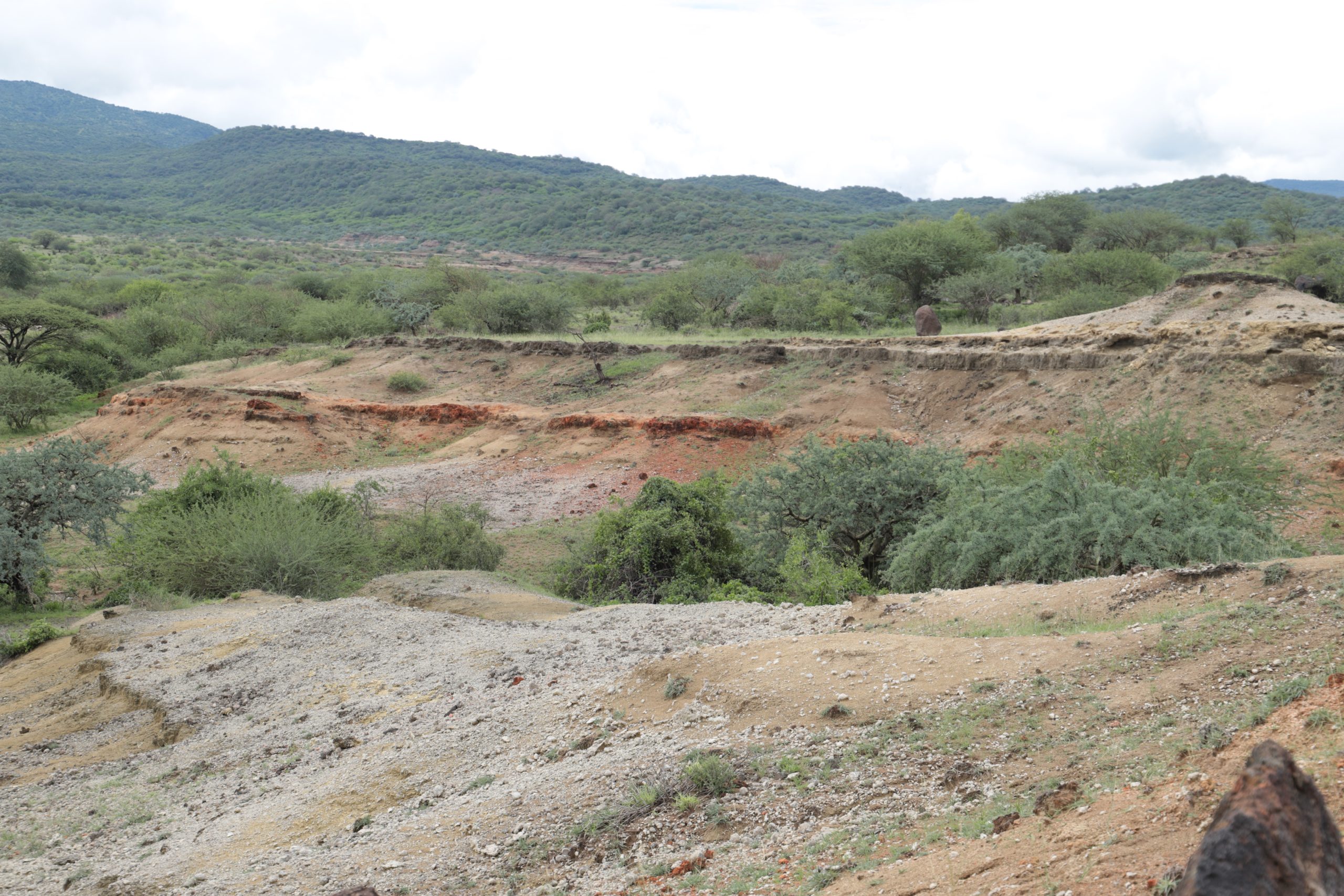
The basin held a large shallow lake through the middle Pleistocene, and the shoreline moved back and forth across the flats as the climate wetted and dried. People worked along that margin because that is where the water and the animals were. When the lake rose, or when a river shifted, the surfaces they had been working on were buried under lake mud and sand rather than scattered.
Two things then preserved the result. The first is diatomite. The thick white sediments visible in the basin are made up of the silica skeletons of diatoms, a lake algae, and they seal a surface quickly and gently. The second is volcanic ash. This is active rift country, the volcanoes around the basin erupted repeatedly, and ash fell across the flats and was incorporated into the sediment pile as discrete layers.
The consequence is a stack of buried ground surfaces separated by datable ash. An archaeologist opening a trench here is not sampling a jumbled deposit of material washed in from somewhere else; the tools sit in the layer they were abandoned on, with the flakes struck off them nearby. That is what in situ means and it is why the phrase does so much work in every description of this site.
A site where tools were collected up and carried in by water tells you only that somebody upstream made tools. A site where they lie where they fell tells you where people stood, what they were doing, and what was lying next to them while they did it. Olorgesailie is the second kind, at a density nothing else matches.
The Dates and the References They Come From
Palaeolithic dates are garbled more often than almost anything else in travel writing, so every figure below is given with the work it comes from.
The chronological framework is the 1990 paper by Alan Deino and Richard Potts, “Single-crystal 40Ar/39Ar dating of the Olorgesailie Formation, Southern Kenya Rift”, in the Journal of Geophysical Research, volume 95, pages 8453 to 8470. Using argon dating on single volcanic crystals from the ash layers, it places the Olorgesailie Formation in its principal exposures along the southern edge of the Legemunge Plain at roughly 500,000 to 1 million years old. The Smithsonian Institution’s Human Origins Program, which has worked here since the 1980s, describes the result of that and subsequent work as making Olorgesailie one of the most precisely dated archaeological sites in the world for the past million years, with two magnetic reversals in the sequence at around 992,000 and 790,000 years ago providing independent checks.
On that framework the Smithsonian places early human occupation of the region between about 1.2 million and 490,000 years ago. Hand axes in the earliest part of the sequence run between about 1.2 million and 900,000 years old, many of them found within about five kilometres of the volcanic outcrops the raw material came from. The team excavated an actual quarry site of about 990,000 years old where hominins struck large flakes off an outcrop, tested the stone and worked the best pieces into hand axes. Hand axe technology at Olorgesailie ends between about 500,000 and 350,000 years ago, replaced by smaller and more varied toolkits.
The National Museums of Kenya, which runs the site, gives the hand axes and their associated debris as over 900,000 years old and the fossil fauna as dating from about 1.2 million years ago. In its 2023 World Heritage submission it describes evidence of human activity in the basin consistently between 1.2 million and 400,000 years before present, and describes the lake basin itself as having existed in the latter part of the middle Pleistocene, probably between 200,000 and 100,000 years ago.
Those figures are not all saying the same thing and should not be blended. The 400,000 and 490,000 year endpoints are close enough to be a matter of where a boundary is drawn. The lake basin figure of 200,000 to 100,000 years in the custodian’s submission is much younger than the occupation dates on the same page and than the formation dating in the geochronology, and no source found for this page reconciles them.
A site occupied across hundreds of thousands of years is routinely reported at its oldest date, and that figure then attaches to everything found there. Olorgesailie is a sequence, not a moment, and any source giving it a single age has flattened it.
The Skull Found in the Hand Axe Bed
In 2003 a partial cranium was recovered at Olorgesailie, catalogued as KNM-OL 45500 and published the following year by Richard Potts, Anna K. Behrensmeyer and colleagues in Science, volume 305, under the title “Small Mid-Pleistocene Hominin Associated with East African Acheulean Technology”.
The specimen is constrained by argon dating, magnetostratigraphy and sedimentary features to between 0.97 and 0.90 million years old, and it was found in the same stratigraphic level as two Acheulean hand axes and several flakes, next to dense deposits of hand axes. The nearby ash layer is dated to about 974,000 years. It carries bite marks from carnivore teeth. Its cranial capacity is estimated at perhaps 700 to 800 cubic centimetres.
What made it notable is its size. The published description records it as possibly the smallest adult or near-adult hominin known from the period between 1.7 and 0.5 million years ago, while retaining features seen in much larger Homo erectus individuals, which the authors read as evidence of wide variation within the hominin populations of that time. The National Museums of Kenya describes it more simply as an adult Homo erectus, somewhat smaller than most others of that species.
Its importance for a visitor is direct rather than technical. Almost everywhere else, the tools and the toolmakers are found separately and connected by inference. Here one was lying in the same layer as the other.
The Missing 180,000 Years and What Came After the Hand Axe
The Olorgesailie outcrop record has a hole in it. Erosion removed the layers covering roughly 180,000 years, and the gap falls squarely across the period when early human behaviour was changing fastest. The material that should have recorded the shift is simply not there in the exposures.
The Smithsonian’s response was to go underground. From 2 September to 4 October 2012 the Olorgesailie Drilling Project took cores from the Koora basin, a flat grassy plain about fifteen miles from the archaeological excavations, recovering 216 metres of sediment from two boreholes with the main core reaching 166 metres below the surface. The cores carry a continuous environmental record of roughly the past 500,000 years, with parts reaching back nearly 700,000, and were taken specifically to supply the rainfall, temperature and vegetation record the eroded outcrop cannot.
What had been happening in the gap became clear in three papers published together in Science on 15 March 2018, led by Alison Brooks of George Washington University, Alan Deino of the Berkeley Geochronology Center and Richard Potts of the Smithsonian. The tools recovered from above the unconformity are Middle Stone Age rather than Acheulean: smaller, more specialised, including points apparently made to be hafted onto a shaft, alongside scrapers and awls. Deino’s dating puts the transition at Olorgesailie at between 320,000 and 305,000 years ago, earlier than the Middle Stone Age had previously been placed in eastern Africa.
Two findings from the same work change what the site means. More than forty per cent of those tools are obsidian, and the Olorgesailie basin has no obsidian in it; the sources lie between roughly fifteen and fifty-five miles away, which means the material was moving across the landscape by exchange or by long-distance procurement. And black and red rocks, manganese and ochre, were found at the sites with evidence that they had been processed for use as colouring material, and had likewise been carried in from elsewhere.
So the basin holds two different stories stacked on top of each other, with a hole between them: a million years of hand axes made from stone picked up within walking distance, and then, above the gap, small worked points made from volcanic glass brought in from a long way off and pigment that had been prepared for use.
Who Excavated Here, and the Date Its Own Custodian Disagrees On
Louis and Mary Leakey found the site and excavation began in earnest in 1943, continuing until 1947. Glynn Isaac then worked the basin as his doctoral research and published the results in 1977 as Olorgesailie: Archeological Studies of a Middle Pleistocene Lake Basin in Kenya, a monograph from the University of Chicago Press that set out the questions about site formation, tool design and early hominin behaviour the place is still worked on to answer. It was Isaac’s excavations that exposed much of the material now displayed where it lies. Richard Potts of the Smithsonian has run long-term fieldwork here with the National Museums of Kenya since the 1980s, extending it into the Koora drilling, and Olorgesailie is read today as much for what it says about a changing landscape as for its tools.
There is a disagreement worth naming because it comes from the custodian’s own material. The National Museums of Kenya’s web page and its World Heritage submission both credit the Leakeys with the discovery in the 1940s and Isaac with the 1960s excavations, which matches the record. Its own site brochure, however, says that teams under Mary and Louis Leakey and Glynn Isaac “took up the excavation in the 1960s”. The 1940s date is the one supported everywhere else and is the one used here.
The World Heritage Position and What It Does Not Mean
Olorgesailie is on Kenya’s Tentative List, not the World Heritage List, and the distinction matters. The National Museums of Kenya submitted it on 30 June 2023 under reference 6665, as a mixed property, nominated under cultural criterion (iii) and natural criterion (viii), located in Kajiado County.
A tentative listing is a state party’s declaration of intent to nominate. It carries no inscription, no World Heritage status and none of the protections that follow one. Kenya has eight inscribed World Heritage properties and this is not among them. Any source describing Olorgesailie as a World Heritage site is wrong.
The submission’s own case is worth reading. Criterion (iii) is argued on the stone tool manufacture and use recorded here between 1.2 million and 400,000 years ago as evidence of a cultural tradition that has disappeared. Criterion (viii) is argued on the basin as one of very few places offering a detailed record of ecological change through the middle Pleistocene. The submission also records that the site was gazetted as a prehistoric site in 1970, that it is managed by the National Museums of Kenya, and that the raised wooden platform exists precisely so that visitors can move around the excavations without walking into them.
One further element of the submission belongs on this page. The National Museums of Kenya records that Mount Olorgesailie, the extinct volcano above the basin, is important to the Ilkeekonyokie Maasai, who used it to perform sacrifices to Enkai, and states that the practice is no longer carried out. That is the custodian’s own account and it is given here as such. Anyone walking on the mountain should know that it is not only a viewpoint.
Visiting the Site
The site is managed by the National Museums of Kenya and opens daily from 8.30am to 5.30pm, all year including weekends and public holidays. Guided tours are led by site guides and museum educators, and taking one is not optional in any practical sense: it is the difference between a field of stones and a story.
There are excavation trenches with catwalks, a museum pavilion, a picnic and camping ground with toilets, washing facilities and secure parking, and standard bandas for overnight stays at the museum’s own published rates. The site lies between two extinct volcanoes, Mount Olorgesailie and Oldonyo Esakut, and the climb up Mount Olorgesailie takes about four hours up and three down. A gorge a kilometre from the museum fills with baboons in the evening. The National Museums of Kenya also calls the site a birdwatcher’s paradise with the highest number of migratory bird species in Kenya, which is its claim rather than a checked one. Camping is by prior arrangement and worth considering, because the basin is exceptionally dark at night. Stargazing in Kenya covers where else that is true.
The heat is the thing to plan around. This is a low, treeless basin with almost no shade and a great deal of glare off pale sediment. Go early, carry far more water than the walking distance suggests, and wear a hat. Collecting stone tools or fragments is illegal, and is also the fastest way to destroy the thing that makes the site worth visiting.
Getting to Olorgesailie and What It Costs
Olorgesailie lies in Kajiado County about 70 kilometres south of Nairobi on the Magadi road, an hour and a half to two hours by private vehicle. The road leaves the city past the Ngong Hills and drops into arid Maasai country, and the drive is a fair part of the attraction. Public transport here is thin, so most visits are self driven or arranged, and the standard pairing is Lake Magadi further down the same road.
On the admission fees published by the National Museums of Kenya on 5 April 2026, implementing Legal Notice No. 79 of 2025 with effect from 7 May 2026 and checked on 21 September 2026, Olorgesailie is grouped with Kariandusi, Koobi Fora, Thimlich Ohinga, Gede and others at KSh 200 for an adult and KSh 100 for a child for Kenyan and East African citizens, USD 6 and USD 3 for residents and the rest of Africa, and USD 8 and USD 4 for visitors from outside Africa. Ticketing is through the government eCitizen platform and the museums service does not take cash at the gate, so arrange payment before arriving.
The banda and camping rates are set by the museum and are published on its own site brochure, but the rate card there carries an evident typographical error in one of its lines, so no figure for overnight accommodation is quoted here. Confirm it with the curator when booking.
Archaeological tours in Kenya places Olorgesailie in the national sequence, and Kariandusi is the northern Rift equivalent.
Questions Visitors Ask About Olorgesailie
Can Olorgesailie be done as a day trip from Nairobi?
Easily, and that is how nearly everyone visits. It is about 70 kilometres south on the Magadi road and the site needs only a couple of hours. Most people pair it with Lake Magadi further down the same road, which makes a full and hot day.
How old is the site?
The Smithsonian Institution’s Human Origins Program places human occupation of the region between about 1.2 million and 490,000 years ago, with the earliest hand axes between about 1.2 million and 900,000 years old. The National Museums of Kenya’s World Heritage submission gives 1.2 million to 400,000 years. The underlying chronology comes from argon dating of the volcanic ash layers, published by Deino and Potts in 1990.
Why is the dating here better than at most sites of this age?
Because the sediments are interleaved with volcanic ash, which can be dated directly by argon dating of single crystals, and because two magnetic reversals in the sequence at around 992,000 and 790,000 years ago provide independent checks. The Smithsonian describes the site as one of the most precisely dated archaeological sites in the world for the past million years.
Was a human fossil found here?
Yes. A partial cranium catalogued as KNM-OL 45500 was recovered in 2003 and published in Science in 2004. It is dated to between 0.97 and 0.90 million years old, was found in the same layer as two Acheulean hand axes, and is described as possibly the smallest adult hominin known from between 1.7 and 0.5 million years ago while keeping features seen in larger Homo erectus.
Is Olorgesailie a World Heritage site?
No. It sits on Kenya’s Tentative List, submitted by the National Museums of Kenya on 30 June 2023 as a mixed property under criteria (iii) and (viii). A tentative listing is a declaration of intent to nominate and carries no inscription and none of the protections that follow one.
Is it suitable for children?
Yes with an early start, and not in the afternoon heat. The catwalks over the trenches hold attention well, but the basin has almost no shade and the glare off pale sediment is severe.
Can you pick up a hand axe?
No. Removing stone tools or fragments is illegal, and it is what has emptied comparable sites elsewhere. The reason there is anything to look at here is that it was left alone.
No operator on the marketplace currently lists a safari to Lake Magadi.
See every Kenya safari